 Religiöse Geometrie in der Urgeschichte
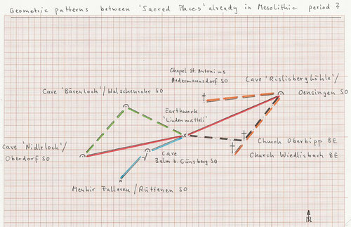
When studying "the target" of some sunken paths and of a strange rock stairway on the Jura slope at about 1000m above Solothurn (the capital of the Swiss canton of the same name), we identified a "sacred spring" (cf. <in German> Quelle Mettlenbach/Günsberg SO), but also observed a surprising geometric pattern between the four major caves in this area.
At the center is an interesting earthwork: 'Lindenmätteli' / Attiswil (Canton Bern) ("small meadow surrounded by linden trees"; 611.875/235.145), a flattened 'platform' on the most western point of a a pronounced hill range on that slope. (The concentration of old linden trees above 800m surprises a bit.)
The cave 'Bäreloch'/Welschenrohr SO ("Bear hole"; 607.025/ 237.510) is equidistant (5.36 km, always measured horizontally) from 'Lindenmätteli' and from the cave 'Nidleloch'/Oberdorf SO (603.465/233.425). The cave 'Balm'/Balm b. Günsberg SO (608.825/233.855) is on an exact straight line with 'Lindenmätteli' and the cave 'Rislisberghöhle'/Oensingen SO (619.775/238.515), and, surprisingly, 'Lindenmätteli' is equidistant (8.53 km) from the cave 'Rislisberghöhle' and from the cave 'Nidleloch' !
These geometric relations between the four caves and the earthwork 'Lindenmätteli' show the usual high precision for prehistoric geometrical relationship of +/- 10/15 m.
Analysing this 'basic network of sacred places', we find the position of 'Lindenmätteli' "overdetermined": Assuming, as it is generally done, that all four caves are of natural origin and therefore 'fixed points', then it seems highly unlikely that such a position as the one of the earthwork 'Lindenmätteli', moreover on a geographically privileged point, has been combined.
We believe therefore it is more likely that one (or more) of these caves was artificially created, and the earthwork 'Lindenmätteli' pre-existed or was built at about the same time.
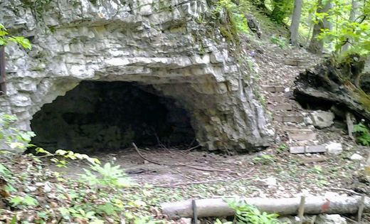
The caves 'Bäreloch' and 'Nidleloch' seem to show a clearly natural origin; 'Rislisberghöhle', less so 'Balm', are obvious candidates for a "tailor-made monument", 'Rislisberghöhle' also for its relatively modest dimensions.
This cave was carefully investigated again over ten years ago and found to be frequented during about 10'000 - 14'000 BC (period called Magdalénien in Europe).
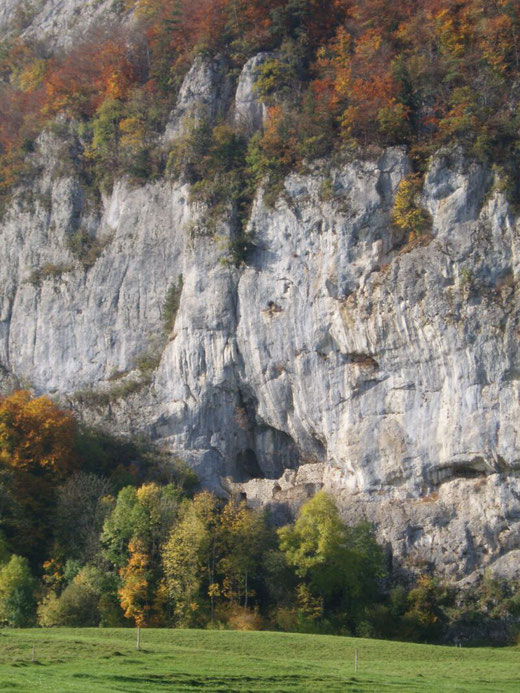
For 'Balm' one should mention that prehistoric artefacts (also attributed to the Magdalénien) were detected there in earlier times. A medieval castle was built into it (today in ruins); this is not a rare case in Switzerland ("Grottenburgen").
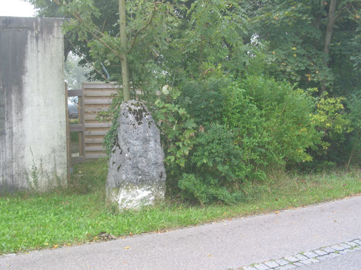
An extract of other, most probably later arranged geometrical relations are also given in the graph: the cave 'Balm' is equidistant (3.29 km) from 'Lindenmätteli' and from the menhir Falleren/Rüttenen SO (606.570/231.425).
The church of Oberbipp BE is equidistant (4.83 km) from 'Lindenmätteli' and from 'Rislisberghöhle'; the straight line 'Rislisberghöhle' - church Oberbipp goes to the church in the small town of Wiedlisbach BE, and the cave 'Rislisberghöhle' is then equidistant (6.32 km) from the church Wiedlisbach and from the chapel St.Antonius in Aedermannsdorf SO.
It is interesting to note here that according to the studies of H.Burgard/B.Grathwohl (book Pyramiden Flut Wiedergeburt) the first temples in Mesopotamia were arranged between them geometrically at about the same time (Magdalénien), albeit on much longer distances.

Kommentar schreiben