 Religiöse Geometrie in der Urgeschichte
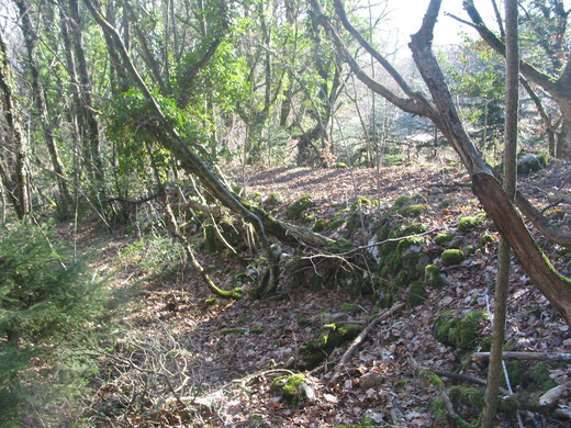
Sunken paths,or better relatively short sunken pathway sectors, are frequent in Switzerland, particularly in the Central Part.
Surprisingly, we find up to this day in Switzerland (and Germany) the view that sunken paths are the result of frequent use and erosion; this viewpoint is somewhat reinforced by the fact that sunken paths are often found on steep hillsides which favours erosion.
However, certain sunken paths are so deep that a natural origin is very unlikely. Other ones are on flat or almost flat terrain; some are even carved into rockstone, however often into relatively easily cut one.
Sunken paths were artificially built !
The hypothesis of a "natural origin" is also encouraged somewhat by the fact that the excavated material was frequently carried away (used for the construction of mottes, small hills or tumuli ?) and therefore not found, but there are quite e few examples where the removed material forms an elevation of earth along the sunken path.
But what was the reason for sunken paths and when were they probably constructed ?
There are numerous indications that sunken paths are linked to prehistoric "cult places" whilst sunken pathway sectors "mark" the trackway which leads to these places (and which were used for religious processions ?). Or were they frequented by pilgrims such as today the 'Way of St.James'?
We have to remind ourselves that the majority of old church places and castles seem to have taken the position of prehistoric "cult places", with many other "sacred sites" being simply abandoned and not reoccupied and therefore often difficult to be recognized.
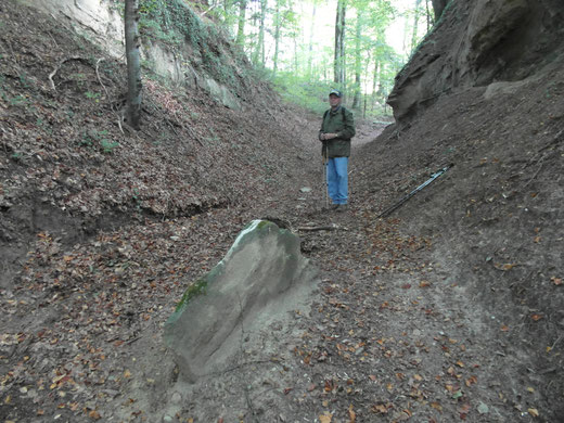
A typical example is the old pathway between the church of Meikirch BE and the former church of the convent Frienisberg/Seedorf BE: about 3 km long it has many sunken path sectors, sometimes multi-track and up to 4 m deep.
Such pathways marked with sunken path sectors, from very ancient times (many exist to this day), are normally not straight and do not lead right away to the "cult places" but often only nearby. They are adjusted to the terrain, e.g. they cross brooks where the land is quite flat and a passage can be arranged with some big stones or some tree trunks.
Fairly often we find very steep ways with sunken path sectors which indicates that they were created in times one still walked.
Why have the constructors of sunken paths often chosen to excavate them on a downward slope ? Maybe to avoid that accumulated cobbles, branches, leaves and dust gradually fill them up; an intense rain of a thunderstorm would "clean" them from time to time. Indeed we have observed horizontal sunken paths in the wood to be almost completely levelled out (of course after many centuries ...).
On the other side a steep sunken path should not be too long for not being washed out during strong rainfall and gradually become a brook bed (example: sunken path leading from center of Dotzigen BE (nearby former church) to Dotzigenberg (P.532)). Or drains have to be built as we find them in the impressive 'Leuenhole' north-east of Burgdorf BE.
However, sunken path sectors were not the sole possibility to mark "special pathways" and to differentiate them from a simple footpath: stones of different sizes were put up on the path's edges, sometimes very large blocks to protect against a slope.
Rather rarely we find paved sectors with such "special pathways", not necessarily on pronounced slopes, and also not frequent are the opposite of sunken paths, namely artificially elevated tracks.
It seems difficult to explain why one observes quite often bundles of sunken paths, up to 6-8, more or less parallel and often interlaced. Was the intention to emphasize in this way the importance of a (main) sunken pathway ?
It should be reminded that earthworks which probably date back to same period also show sometimes multiple terraces or earth walls (e.g. 'Poëpe' (P.511)/Ependes VD or 'Tüfelsburg' (P.549) east of Rüti b.Büren BE).
Regarding the origin of these sunken paths we postulate their construction in the Neolithic period, possibly the Bronze age, for which there are some indications.
It is interesting to note that A.Meynier has proposed this already 1943 in France ("Champs et Chemins en Bretagne"): "... Signs of a past civilisation, the sunken path and the fields are to be considered as a archaeological testimony, equal to big menhirs." However, this viewpoint was discarded by Professor Louis Chaumail in 1949 and thanks to his academic influence and power successfully "buried".
If our thesis regarding sunken path sectors was correct, then every old pathway marked with sunken path sectors leads to at least one "cult place", often to several ones. Since not always churches, chapels, crosses, castles, towers have taken these positions, they are often not easy to find out, for the ground surface has sometimes not been artificially modified. Beside caves, earthworks, mottes, earth walls etc. we guess there may exist a great number of undiscovered prehistoric "sacred sites", e.g. mountain tops.


Kommentar schreiben