 Religiöse Geometrie in der Urgeschichte
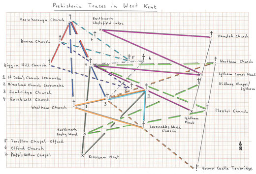
Despite the popular belief that Moats are medieval, it seems that they have a prehistoric origin as evidenced in this study regarding precise geometrical patterns (which seem to have a prehistoric basis) in West Kent.
<Further clear examples did not find space in this graph.>
Our assumption is that they were excavated to mark in their center a place of worship ("cult place"), - the ditches filled often with water depending on the subsoil – but in medieval times many castles were built in moats since they offered some protection, and also because aristocracy seeked to occupy "cult places" as was the case in Continental Europe.
A precise straight line goes from Broxham Moat/Hever via the earthwork Derby Wood/Westerham (546.000/150.910) to the church in Knockholt. Broxham Moat is exactly equidistant (10.55 km, always measured horizontally) from this church and the St.John's church (St.John's Hill URC) in Sevenoaks.
A straight line (length 12.85 km) goes from Knockholt church to this St.John's church and then to Igtham Moat ("Mote"). The same distance is found then between Knockholt church and the Igtham Court Moat (559.600/157.780), between Igtham Court Moat and an earthwork at Chelsfield Lakes/Chelsfield (547.900/163.030) and between this earthwork and the church in Stansted, altogether four times! A precise straigh line goes from the Stansted church via Igtham Court Moat to Igtham Moat!
All this seems far from accidental and appears to be a "geometrical construction".
The church in Plaxtol is equidistant (14.39 km) from the Knockholt church and the earthwork Derby Wood, and again we find the same distance a third and a fourth time between Derby Wood and the chapel in Oldbury/Igtham and between the Knockholt church and the church in Wrotham. The straight line Wrotham church - Plaxtol church goes to the former Castle Tonbridge.
The church in Sundridge is equidistant (13.22 km) from the Wrotham church and the former Castle Tonbridge.
Another, most probably not fortuitious geometrical pattern is the following: the above mentioned St.John's church in Sevenoaks is equidistant (4.62 km) from that church in Sundridge and from the church in Sevenoaks Weald. The straight line St.John's church - Sundridge church leads to the church in Westerham which in turn is precisely equidistant (8.55 km) from St.John's and the Sevenoaks Weald church!
Once more, our prehistoric ancestors tried to achieve an interconnected network: the church of Farnborough is equidistant (10.05 km) from the churches of Westerham and Sundridge, and the straight line Farnborough church - Sundridge church passes precisely across the Knockholt church. The church in Otford is equidistant (6.07 km) from the churches in Knockholt and Sundridge.
The church in Farnborough is then equidistant (5.73 km) from the churches in Knockholt and Biggin Hill, and the straight line Farnborough church - Biggin Hill church passes through the church in Downe. The Riverhead church in Sevenoaks is equidistant (9.90 km) from the churches of Downe and Biggin Hill.
Finally, the Twitton chapel in Otford is equidistant (8.27 km) from the churches in Farnborough and Downe, and the straight line Farnborough church - Twitton chapel goes through the chapel in Pratt's Bottom.
Remains the question when were the moats constructed? Since they are linked to earthworks it may have started in the neolithic period, but probably continued for a long time thereafter.
Kommentar schreiben